
From satellite signal to vehicle tracker, network, fleet platform, and operational decision

For a fleet manager, the useful question is not simply “How does GPS work?” It is “How does a position calculated inside a vehicle become reliable information on a fleet dashboard?” This guide follows that complete data path and explains what GPS can measure, what requires additional sensors, how accurate tracking is, and how to choose a system for commercial operations.
GPS fleet tracking combines satellite positioning, a vehicle or asset tracker, mobile or satellite communications, and fleet software. Together, these components show where vehicles and equipment are, record their movement, and turn location and sensor data into routes, alerts, reports, and operational decisions.
Table of Contents
Key takeaways
- GPS is one satellite navigation system; GNSS is the broader category that also includes Galileo, GLONASS, BeiDou, and other regional systems.
- A vehicle tracker normally uses signals from at least four satellites to calculate a three-dimensional position and correct its internal clock error.
- The tracker, not the satellite, sends location data to the fleet platform. It usually uses a cellular network, although satellite or radio communications may be used in remote operations.
- GPS provides position, speed, time, and course over ground. Fuel level, engine data, driver identity, temperature, and door status require vehicle interfaces or additional sensors.
- Loss of mobile coverage does not necessarily mean loss of GPS. A properly configured tracker can continue calculating and storing positions, then upload them when connectivity returns.
- Installation quality, antenna placement, reporting rules, offline memory, network compatibility, and software configuration matter as much as the advertised tracker specification.
What is GPS fleet tracking?
GPS fleet tracking is the use of satellite positioning and connected tracking devices to monitor commercial vehicles, mobile equipment, trailers, and other assets. The location data is sent to a fleet platform where authorized users can view current status, replay routes, configure alerts, and create operational reports.
GPS tracking is not the same as turn-by-turn navigation. A navigation device helps a driver reach a destination. A fleet tracking system creates remote operational visibility for dispatchers, fleet managers, safety teams, maintenance teams, and business systems.
A complete fleet tracking solution normally includes four layers:
- A GNSS receiver calculates position and time from satellite signals.
- A tracker combines that position with ignition, movement, vehicle, and sensor data.
- A communications module sends records through a cellular, satellite, or radio network.
- Fleet software stores, displays, analyzes, and shares the information.
GPS tracking is therefore one part of a broader vehicle telematics system. Telematics connects GPS with communications, sensors, diagnostics, software, reporting, and business workflows.
How does GPS fleet tracking work?
The process can be understood as a five-stage data chain.
1. Satellites broadcast position and time
Navigation satellites continuously transmit radio signals containing precise time and orbital information. They do not follow a specific truck and they do not receive information from an ordinary fleet tracker.
2. The receiver calculates its position
The GNSS module inside the tracker measures the apparent travel time of signals from multiple satellites. It uses these measurements to estimate latitude, longitude, altitude, time, speed, and course over ground.
3. The tracker adds operational data
The device may add ignition state, external power voltage, movement events, accelerometer events, digital inputs, and readings from vehicle interfaces or connected sensors. The exact data depends on the hardware and installation.
4. Records are transmitted
Most commercial trackers send data through a cellular modem. Remote mining, maritime, humanitarian, or cross-border projects may use satellite communications or a hybrid design. When no network is available, a tracker with store-and-forward capability keeps records in memory.
5. Fleet software turns records into information
The platform places positions on a map, reconstructs trips, detects stops, applies geofence rules, sends notifications, and creates reports. It can also combine location with fuel, driver, maintenance, temperature, cargo, or video data.
GPS vs GNSS vs cellular tracking
These terms describe different parts of the system and should not be used interchangeably.
| Term | What it means | Role in fleet tracking |
|---|---|---|
| GPS | The satellite navigation system operated by the United States | One source of positioning and timing signals |
| GNSS | The general category of global and regional satellite navigation systems | Allows compatible receivers to use GPS, Galileo, GLONASS, BeiDou, and other systems |
| Cellular network | A mobile communications network such as LTE, LTE-M, or NB-IoT | Carries tracker records to the server; it does not normally calculate the satellite position |
| Cell-based location | An approximate position derived from mobile network information | Can provide a fallback or supporting estimate, but is usually less precise than a good GNSS fix |
Multi-constellation support generally improves satellite availability and geometry, especially where buildings, terrain, trees, or containers restrict the view of the sky. It does not guarantee a position in every environment. Tunnels, underground parking, metal structures, interference, and poor antenna placement can still block or degrade signals.
Satellite counts change as spacecraft are launched, commissioned, maintained, or retired. For evergreen content, it is safer to link to official constellation status pages than to promise a permanent number.
How does a tracker calculate its position?
Each navigation satellite broadcasts its position and the time the signal was transmitted. The receiver compares that information with the time the signal arrives. Because radio signals travel at approximately the speed of light, the measured travel time provides an apparent distance, often called a pseudorange.
This positioning method is commonly explained as trilateration: finding a location from distances to known points. In a simplified geometric model, three exact ranges can constrain a three-dimensional position. An ordinary receiver, however, does not carry an atomic clock. It must solve for four unknowns: three position coordinates and its own clock bias. That is why a normal three-dimensional GNSS fix usually requires signals from at least four satellites.
A clock error of one microsecond corresponds to roughly 300 metres of signal travel. The additional satellite measurement allows the receiver to estimate and correct this clock offset instead of requiring an atomic clock inside every tracker.

Why the first fix can take longer
Time to first fix depends on what information the receiver retained and on current signal conditions.
- A cold start occurs when valid satellite orbit data and a recent position are not available. Under good conditions it may take around 30 seconds, and difficult conditions can extend the delay.
- A warm start begins with some useful stored information but may still require updated satellite data.
- A hot start uses recent position, time, and orbit information and can normally produce a fix much faster.
Parking a vehicle for a weekend does not automatically guarantee a cold start. The result depends on tracker design, backup power, sleep mode, retained data, antenna view, and firmware configuration.
Assisted GNSS can obtain time and satellite data through a network service instead of waiting to decode all of it from the navigation signal. Compatible receivers can often achieve a position in seconds, but actual performance remains device- and environment-dependent.
What is inside a vehicle GPS tracker?
A fleet tracker is more than a GNSS receiver with a SIM card. Common components include:
- GNSS module for position, time, speed, and course over ground while moving;
- cellular, satellite, or radio modem for data transmission;
- microcontroller and memory for logic, event processing, and offline storage;
- accelerometer for motion, harsh-driving, impact, and tamper events;
- internal backup battery in supported models;
- CAN, OBD, FMS, 1-Wire, RS-232/485, Bluetooth, and digital or analog interfaces;
- antennas and power-conditioning circuitry.
Some trackers combine inertial sensors with wheel-speed, vehicle, or other data to support dead reckoning during short GNSS interruptions. An accelerometer or gyroscope by itself does not guarantee accurate dead reckoning; the function requires appropriate hardware, calibration, and sensor-fusion software.

What data comes from GPS, and what requires sensors?
| Data | Typical source | Important limitation |
|---|---|---|
| Position and time | GNSS receiver | Quality depends on satellite visibility, geometry, antenna, receiver, and environment |
| Speed and course | GNSS receiver | Course over ground is most meaningful while the vehicle is moving |
| Ignition and power state | Tracker input or voltage logic | Depends on correct wiring and configuration |
| Engine hours, RPM, odometer, diagnostic codes | CAN, OBD, or FMS interface | Only available when the vehicle exposes compatible parameters |
| Fuel used | Vehicle interface or calculated telemetry | Availability and accuracy vary by vehicle and integration |
| Fuel level | Vehicle data or a calibrated fuel level sensor | GPS alone cannot measure tank level |
| Driver identity | iButton, RFID, app, tachograph, or another ID method | Requires a reliable driver-assignment process |
| Temperature, door, cargo, pressure | Connected sensors and inputs | Requires suitable sensors, installation, calibration, and alert rules |
| Video events | Connected camera or mobile DVR | Requires video hardware, storage, communications, and access controls |
This distinction prevents a common purchasing mistake: buying a basic location tracker and expecting it to produce fuel, engine, cargo, or driver data without compatible interfaces and sensors. TAI Capital’s GPS tracking equipment can be selected around the required data sources rather than location alone.
Active vs passive GPS tracking
An active tracker sends records to a remote platform. “Real time” normally means near-real-time reporting at configured intervals or events; coverage, power, and reporting rules affect latency. A passive logger stores positions for later retrieval and cannot provide immediate remote alerts. Many fleet devices combine active reporting with offline buffering when a network is unavailable.
Types of GPS tracking devices
| Device type | Best fit | Main considerations |
|---|---|---|
| Hardwired vehicle tracker | Trucks, buses, delivery and service fleets | Stable power, tamper resistance, more interfaces; professional installation required |
| OBD plug-in tracker | Light vehicles and fast pilots | Quick deployment; can be unplugged and may expose limited vehicle data depending on model |
| Battery-powered asset tracker | Trailers, containers, generators, equipment | Reporting frequency, acquisition time, temperature, network quality, and battery capacity affect service life |
| Solar-assisted asset tracker | Outdoor trailers and long-term assets | Needs appropriate light exposure, mounting, sealing, and battery management |
| OEM embedded telematics | Newer connected vehicles | Data access, API terms, mixed-fleet coverage, retention, and supplier dependency must be evaluated |
| Smartphone or workforce app | Temporary tracking and field teams | Depends on user permissions, phone power, OS restrictions, privacy policy, and connectivity |
No single device class is best for every fleet. A mixed fleet may require hardwired trackers for trucks, OBD devices for short-term vehicles, and battery or solar devices for unpowered assets.
Positioning interval vs reporting interval
Two settings are often confused:
- The positioning or logging interval controls how often the device calculates or stores a position. Frequent GNSS acquisition improves detail but consumes power.
- The reporting or transmission interval controls how often stored records are sent to the platform. It affects latency and data use.
The word “polling” is ambiguous because some suppliers use it for a server request, others for a device update, and others for a GNSS fix. Specifications should use explicit terms.
Good tracking configurations combine scheduled reports with event-based logic. A tracker may send on ignition, significant heading change, movement start or stop, harsh driving, power loss, tampering, or geofence activity, with a periodic heartbeat between events. Whether this reduces data usage depends on route complexity, event thresholds, message size, protocol overhead, sensor payloads, retries, and roaming conditions.
Fleet software always has the last reported state. It does not have a new position until the next record arrives. Some platforms connect or interpolate points for display, so a sparse track can appear to cut a corner. More appropriate logging and event rules improve route representation but cannot recreate positions that were never recorded.

Offline buffering
When mobile coverage is lost, a tracker with sufficient memory can continue recording positions and upload them later. Buffer capacity should be evaluated as a duration, not only as “number of points.” Ten thousand records last for very different periods at a five-second interval and a fifteen-minute interval.
Before deployment, test:
- the expected logging interval;
- available memory and overwrite behavior;
- upload order after reconnection;
- duplicate handling;
- time synchronization;
- alerts for prolonged disconnection.
sectetur adipiscing elit. Ut elit tellus, luctus nec ullamcorper mattis, pulvinar dapibus leo.
How accurate is GPS fleet tracking?
There is no single accuracy number that describes every device in every location.
The US government’s GPS accuracy commitment applies to the signal in space, not to the position shown by a vehicle tracker. GPS.gov states a daily global average user range error of no more than 2 metres with 95% probability across healthy satellites in constellation slots. It also explains that actual user accuracy depends on satellite geometry, signal blockage, atmospheric conditions, and receiver design.

Under open sky, a standard receiver may produce positions within a few metres. Accuracy can become significantly worse near high-rise buildings, warehouses, bridges, trees, container stacks, and reflective metal structures. Reflected signals create multipath error and may place a vehicle on the wrong road or on the other side of a facility.
Common causes of poor or missing positions include:
- tunnels, underground parking, covered loading areas, and metal roofs;
- high-rise “urban canyons” and reflective structures;
- poor antenna placement or damaged antennas and cables;
- weak vehicle power, incorrect sleep configuration, or device reset;
- radio interference or jamming;
- low-quality receiver or outdated firmware;
- mapping or address errors that are separate from GNSS accuracy.
Dilution of precision describes satellite geometry. Satellites spread across the sky normally provide a stronger geometric solution than the same number clustered in one direction.
High-precision techniques such as RTK or differential corrections can achieve centimetre-level results in suitable applications. They are valuable for surveying, precision agriculture, machine control, and some port or construction workflows. Ordinary dispatch and route monitoring usually do not need centimetre accuracy; the system should be selected according to the operational decision it must support.
Benefits of GPS fleet tracking
The value comes from operational decisions, not from placing dots on a map:
- faster dispatch, delay investigation, and customer arrival updates;
- visibility into routes, mileage, stops, working time, and underused assets;
- movement, power-loss, tamper, and geofence alerts for asset protection;
- speed and accelerometer events for safety review and driver coaching;
- mileage, engine hours, and diagnostics for maintenance planning;
- fuel, temperature, cargo, and door-event analysis when compatible sensors are connected.
GPS alone cannot measure fuel or cargo conditions. See TAI Capital’s fuel monitoring equipment for examples of the additional sensor layer.
GPS fleet tracking use cases
- Logistics and service fleets: route progress, stops, dispatch, proof of arrival, and customer updates.
- Construction and agriculture: location, engine hours, site utilization, unauthorized movement, and maintenance.
- Passenger transport: route adherence, schedule analysis, safety events, and passenger-information integrations.
- Cold chain: location combined with temperature sensors, door events, and alerts.
- Trailers and containers: low-frequency location, movement detection, inventory, and yard visibility.
- Rental and leasing: mileage, utilization, boundary alerts, and recovery support, subject to contractual and privacy requirements.
GPS tracking vs geofencing vs telematics
| Capability | Primary purpose | Relationship |
|---|---|---|
| GPS/GNSS tracking | Determine and record location, movement, speed, and time | Provides the location data |
| Geofencing | Detect activity in relation to a defined virtual area | Applies a location-based rule to tracking data |
| Telematics | Combine location, communications, vehicle data, sensors, software, and workflows | The broader operational system |
| Fleet management platform | Store, visualize, analyze, alert, and integrate fleet information | Turns telematics records into usable processes |
A fleet can have GPS without advanced telematics, but a modern telematics platform normally uses GNSS as one of several data sources. Learn more in TAI Capital’s guides to geofencing and vehicle telematics.
What does GPS tracking look like in fleet software?
In a platform such as Wialon, authorized users can monitor units, replay tracks, review reports, configure geofences and notifications, and combine location with sensor or vehicle data. Dashboards aggregate this information for management, but their value still depends on reliable installation, configuration, and operational ownership.
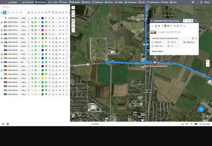
For essential monitoring, Wialon Lite may fit a smaller operation. Fleets needing advanced reporting, sensors, integrations, and scalable cloud deployment can evaluate Wialon Hosting.
How to choose a GPS fleet tracking system
Start with the operational problem, then select hardware and software. Check:
- the decisions the project must support: dispatch, theft response, fuel, safety, maintenance, cargo, compliance, or utilization;
- vehicle type, electrical system, permanent power, CAN/OBD/FMS access, mounting location, and tamper risk;
- operating conditions such as UAE heat, sun, dust, vibration, sealing, and long parking periods;
- supported radio bands, operator coverage, roaming, SIM management, LTE/LTE-M/NB-IoT availability, and lifecycle in every country of operation;
- offline storage duration at the proposed logging interval;
- battery capacity, GNSS acquisition, network retries, temperature, and reporting rules for unpowered assets;
- tracker inputs, sensor protocols, vehicle compatibility, platform decoding, reports, alerts, API access, and data ownership;
- documented installation, commissioning, calibration, training, replacement, and support procedures.
Do not buy around a generic label such as “4G,” “real time,” or “battery life up to several years.” Test the exact device, configuration, operator, asset, and route profile.
TAI Capital works from this engineering approach: audit the fleet, define the data and decisions, select compatible equipment, test a pilot, configure the platform, validate results, train users, and scale the deployment. This is especially important for the operational conditions described in our guide to fleet management challenges in the UAE.
Privacy and security considerations
Vehicle location can be sensitive operational data and may also become personal data when it can be connected to an identifiable driver or employee. Requirements vary by country, contract, vehicle ownership, and purpose of monitoring.
Good practice includes documenting the purpose and lawful basis, informing affected people, defining private-use rules, limiting access by role, securing communications and authentication, setting retention periods, and reviewing API and export permissions.
Privacy should be designed into the project before installation. A technically possible report is not automatically an appropriate one.
GPS tracking implementation checklist
- Define goals and baseline KPIs.
- Inventory vehicles, assets, interfaces, and environments.
- Map every required data point to its source.
- Select hardware, communications, software, and sensors.
- Install and validate a representative pilot.
- Test positioning, trips, buffering, sensors, alerts, and reports.
- Configure access, privacy, dashboards, and escalation workflows.
- Train users, measure results, correct the configuration, and scale.
Frequently asked questions
What is GPS fleet tracking?
GPS fleet tracking uses satellite positioning, connected vehicle or asset trackers, communications networks, and fleet software to monitor location, movement, routes, events, and related operational data.
How does a GPS tracker work in a vehicle?
The tracker’s GNSS receiver calculates position from satellite signals. The device adds available vehicle and sensor data, stores records, and sends them to a fleet platform through a cellular, satellite, or radio connection.
Does a GPS tracker need a SIM card?
Many active vehicle trackers use a SIM or embedded SIM for cellular communications. A passive logger does not need a SIM, and some remote systems use satellite or radio communications instead.
Does GPS work without mobile coverage?
Yes. The receiver can calculate position without mobile coverage. Remote users will not receive new records until communications return. A tracker must support offline storage to preserve the missing period.
Will a tracker work when the vehicle is switched off?
It depends on wiring, sleep configuration, backup battery, vehicle power management, and device design. A hardwired tracker may remain connected to permanent power while reducing activity to protect the vehicle battery.
How accurate is a vehicle GPS tracker?
Under open sky, standard equipment may be accurate within a few metres. Buildings, tunnels, metal structures, reflected signals, antenna placement, interference, satellite geometry, and receiver quality can make the result worse.
What is the difference between GPS and GNSS?
GPS is the US satellite navigation system. GNSS is the broader category that includes GPS and systems such as Galileo, GLONASS, and BeiDou.
Can GPS tracking measure fuel consumption?
GPS alone cannot measure fuel level or actual engine fuel consumption. Fuel information requires compatible vehicle data, calculations based on vehicle parameters, or a calibrated fuel sensor.
Can GPS tracking identify the driver?
Not by location alone. Driver identification requires an iButton, RFID card, app, tachograph integration, assignment workflow, or another identity source.
What happens in a tunnel or underground parking area?
The tracker may lose its satellite fix. Supported systems can estimate movement for a limited period using dead reckoning, but error grows over time. Normal positioning resumes when adequate signals return.
Is GPS tracking legal for company vehicles?
Rules vary by jurisdiction and context. Organizations should document the purpose, inform affected people, limit monitoring and access, establish retention rules, and obtain legal advice where required.
Conclusion
GPS fleet tracking is not a single device or a map feature. It is a data chain from satellites to a receiver, from the tracker to a communications network, and from the server to an operational workflow.
Reliable results depend on selecting the right tracker, installing it correctly, configuring useful logging and reporting rules, integrating the necessary sensors, validating the data, and training people to act on it.
TAI Capital designs and integrates GPS tracking and telematics solutions for commercial fleets, vehicles, machinery, trailers, and connected assets. If you are selecting hardware, replacing legacy devices, or improving an existing monitoring system, contact the TAI Capital engineering team for a project assessment.
Sources and technical references
- GPS.gov, “GPS Accuracy”: https://www.gps.gov/gps-accuracy
- GPS.gov, “GPS Performance”: https://www.gps.gov/gps-performance
- GPS.gov, “Other Global Navigation Satellite Systems”: https://www.gps.gov/other-global-navigation-satellite-systems-gnss
- GPS.gov, “Trilateration”: https://www.gps.gov/trilateration
- European GNSS Service Centre, “Galileo Constellation Information”: https://www.gsc-europa.eu/system-service-status/constellation-information
- u-blox, “Assisted GNSS”: https://www.u-blox.com/en/technologies/agnss-assistnow
- Wialon, “Vehicle Tracking System”: https://wialon.com/en/vehicle-tracking-system
Need help selecting a GPS tracking system?
TAI Capital can assess vehicles, operating conditions, hardware, sensors, connectivity, and fleet software requirements.
Request a project assessment